


 609-494-5739


Home Port Charts
Home Port Charts
SKU: HP-03


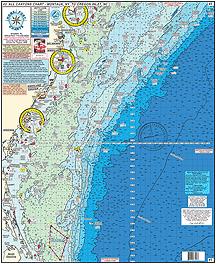
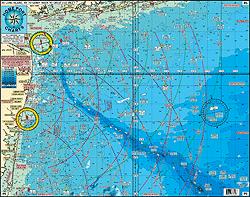


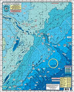
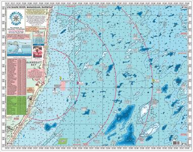


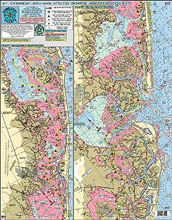

Chart ID:
#3 - GPS ALL Canyons Chart
Montauk Point, NY to Oregon Inlet, NC
Shows: Montauk Point, Shinnecock, Fire Island, Sandy Hook, Shark River Inlet, Manasquan Inlet, Barnegat Inlet, Absecon Inlet, Cape May Inlet, Ocean City, MD Inlet, Wachaprague, Rudee Inlet, to Oregon Inlet
CANYONS: Chicken Canyon, Hudson Canyon, Toms, Mey, Hendrickson, Lindenkohl, Carterett, Berkeley, Spencer, Wilmington, Baltimore, North Vries, South Vries, North Heyes, South Heyes, Poorman's, South Poorman's Washington, and the Norfolk Canyon
Fishing Grounds: Mud Hole, Monster Ledge, Mako Hotel, The Point, No Name Shoal, 42 Fathom Basin, The Tongue, The Flats, Babylon Valley, Emery Canyon, Uchupl Canyon, West Twin Dipper Canyon, Letters South, Letters North,1000 Fathom Tip, Jones Valley, Hudson Seamount, Mey Canyon, Hendrickson Canyon, The Funnel, Doc Strobel, Toilet Seat, Alligator Bight, North Vries and South Vries Canyons, Triple 0, 461, 471 Hump, Rock Pile, Lobster Pots,Tarheel Mountain, Northeast Grounds, and more.
* Laminated - Waterproof
* Color coded depth and contour curve lines
* LAT/LON coordinated for every inlet
* 84+ Wrecks and Reefs with GPS coordinates
* Depths in Fathoms
#6 MUDHOLE CHART- LONG ISLAND NY to SANDY HOOK to GREAT EGG INLET
Awesome Bottom Structure
Shows Sandy Hook , Shark River, Manasquan, Barnegat, Beach Haven, Atlantic City, Ocean City Out 50 plus Miles
* Laminated- Waterproof
* 10 mile radius lines from each inlet
* Color coded depth and contour curve lines showing Holes, Shoals, Lumps, and Bumps
FISHING GROUNDS with DGPS LAT/LON Coordinates; Mud Hole, The Glory Hole, Chicken Canyon, Cholera Bank, Anglers Bank, Acid Waters, Shrewsbury Rocks, The Farms, Tarpon Lump, England Bank, Augie's Lump, Klondike Bank, Monster Ledge, Humpty Dumpty, Little Italy, Shark Ledge, Triple Wrecks, East Lump, Seaside Lump, Tolton Lump, Oleys Lump, ESS Ledge, North Hole, Dusky Hole, East Barnegat Ridge, The Star, Harvey Cedars Lump, Red Tower Lump, Hambone, Dog Lump, A.C. Ridge, Fingers, Table Top, Avalon Shoal, Margarita Lump, Sea Isle Ridge, The Cigar, Jim's Hole, 750 Square, Lemke's Canyon, Sea Isle Lump, Cuma Lumps, and many more.
DGPS NUMBERS FOR WRECKS: Lido, Navy Barge, Ocean Prince, Wolcott, Oregon, Bonanza, San Diego, Hilton Castle, Reggie, Light Ship Wreck, Linda, 3 Sisters, Bald Eagle, Eurreka, Happy Days, USS Tarantula, Goulandris II, Bendix, Gloria and Doris, Florence, Burnside, Brencen, Arundo II, Ednas Bottom, USCG Catamount, Somerstod, Anastasia, Cow Wreck, Maurice Tracy, Truro, Vixen, Hargraves, Tolten, Sea Hag, Resor, West Wreck, Lexington, Bidevind, Texas Tower, Chesapeake, San Saba, Brick Wreck, Huntington, Great Isaac, Spanish, Reliance, H. Ruse, Oklahoma, Skukas, Crystal Gayle, Gloria, Moran, Almirante, Astra, Teaser, Burrows, Oil Wreck, $25 Wreck, Blackie, San Hose, Cayru, Salem, Mud Wreck, Martino, New Rhodes, 28 Mile Wreck, Capt Walt. Hendee, Bass Barn, EB Cole, Kahuka, and many, many more.
#7 Manasquan, Barnegat, Beach Haven, Absecon to Corsons Inlet
Near shore - out 15 plus miles
Shows Artificial Reefs:
Sea Girt, Shark River, Axel Carlson, Barnegat Light Reef, Garden State North, Garden State South, Little Egg, Great Egg Reef, Atlantic City Reef, Townsends Inlet Reef.
* 3 nautical mile line shown
* 5 mile radius lines from each inlet shown
* laminated - waterproof
* Bottom structure shown: holes, peaks, shoals
* color coded depth & contour curve lines
Fishing Grounds Shown:
Klondike Bank, Humpty Dumpty, Little Italy, Manasquan Ridge, "EN" Rocks, Tolton Lump, ESS Ledge, Oley's Lump, North Barnegat Ridge, West Hole, South Barnegat Ridge, Harvey Cedars Lump, Atomic Lump, Brigantine Shoal, Lobster Hole, Cuma Lumps, Coral Bottom, Stone Beds, Table Top, Sea Isle Lump, Dog Lump, Hambone, Triple Lumps, AC Lobster Pots
Wrecks with DGPS Co-ordinates:
Blue Dog II, Blue Dog I, Mildred, Cadette, Mahogany, Logwood, Sea Girt Wreck, Dave Moran, Mohawk, Coffee, Shopping Cart, Queen, Lana Carol, Sovereign, Duncan, Emerald City, Anastasia, Tolton, Truro, Maurice Tracy, Gov Mansion, Hankins, Gulf Trade (stern), Vixen, Hargraves, Spanish, Hammies, Gulf Trade (bow), Chesapeake, Reliance, San Saba, Great Isaac, YO 153, Brick Wreck, Magnus, Summer, Good Ship Lollipop, Crystal Gayle, Russell, Wellington, S. Cotles, Glory Wreck, Hornet, Moran, Almirante, Astra, SE Wreck, Pet Wreck, Old Mud Digger, Florida, Oil Wreck, Clam Boat, Swanaka, San Jose, Blackie, $25 Wreck, The Libra, Salem, Bay Jack, Martino, and more.
#10 "TUNA CHART' Barnegat, NJ to Ocean City, MD
ALL GPS
Awesome Bottom Structure - Holes-Shoals-Lumps-Bumps
Shows: Barnegat Inlet, Little Egg Inlet, Absecon Inlet, Great Egg Inlet, Cape May Inlet, Indian River DE Inlet and Ocean City MD inlet
* 10 Mile radius lines from each inlet
* Out 50 Miles
* Laminated - waterproof
* Color coded depth and contour curve lines
* 89 + Wrecks and Reefs like: Anastasia, Cow Wreck, Tolton, Maurice Tracy, Bone Wreck, Vixen, Hargraves, Resor, Sumner, Gulf Trade, Chesapeake, San Saba, Choctaw, Spanish Wreck, Blackie Wreck, Salem, Evelyn K, Varanger, Capt. Walt Hendee, Champion, Ammo Wreck, Misty Blue, Jacob Jones, Bimbo, Manhattan, TJ Hooper, USS Nina, Miss Arlene, Muff Diver, USS Blenny, St Augustine, and many more.
*Fishing Grounds with DGPS LAT/LON Coordinates: The Slough, The Ledges, Tolton Lump, Barnegat East Ridge, Dusky Hole, ESS Ridge, Table Top, Barnegat Ridge, 45 Square, Triple Lumps, Stone Beds, Sea Isle Lump, Avalon Shoal, Cuma Lumps, The Fingers, Brigantine Shoal, Margarita Lump, Sea Isle Ridge, Jim's Hole, Bent Chunk, NE Lump, Middle Lump, The Pimple, The Cigar, East Lump, The Triple Wrecks, The Elephant Trunk, North Dump Site, 19 Fathom Lump, South Dumpsite, Massey's Canyon, The Tea Cup, The Chicken Bone, Hambone, South Paw, 20 Fathom Fingers, The Hotdog, Hot Dog Bun, Sausages, Jack's Spot, Notch of the Dog
#11 ICW BARNEGAT to GREAT EGG INLET
Including the ENTIRE Mullica River out to Sweetwater
Great for Kayaking!
Shows: Barnegat, Beach Haven, Little Egg, Brigantine, Absecon, and
Great Egg Inlets
Fishing Spots: Myer's Hole, Oyster Creek Channel, Double Creek Channel, Long Point, Mud Cove, Drum Point, Neuman's Thoro, Shooting Thoro, Weakfish Thoro, Sloop Thoro, Broad Thoro, Rainbow Channel, and many more
*Corrected ICW Channels shown in yellow
*Holes and Fishing Grounds shown throughout Back Bays
*Color coded depth and contour curve lines
*All lighted markers, buoys, and daymarkers are shown
*Bridges with their vertical clearances at mean low water
*All shore points and towns named
*Boat ramps and Marinas shown
*Laminated-waterproof
#12 CANYON CHART ENLARGEMENT
Hudson Canyon to the South Poorman's
AWESOME BOTTOM STRUCTURE
Shows distances from each inlet to the Canyons!
*30 Fathom Curve east past 1000 Fathoms
*Shows: The Glory Hole, Hudson, Tom's, Berkely, Carteret, Lindenkohl, Spencer, Wilmington, Baltimore, Poormans and the South Poormans Canyons and 500 Fathom Lumps outside Washington Canyon
*Laminated-waterproof
*Color coded depth and contour curve lines
*Peaks and Canyons shown with GPS LAT/LON coordinates
*Fishing Grounds Shown: The Glory Hole, No Name Shoal, 42 Fathom Basin, The Point, The Flats, The Tongue, 200/100, The Bombs,Chicken Canyon, Jones Valley, Babylon Valley, The Letters, The Rabbit Ears, The Funnel, The Lobster Claw, The Elephant Trunk, The 500 Square, The West Notch, The 500 Fathom Lumps and many more.
Wrecks Shown with with GPS LAT/LON coordinates: Bacardi, Texas Tower, Olinda, Bidevind, Lexington, West Wreck, Larson, Huntington, Herb Parker, Haskell, U-869 Sub, Isabel Wiley, EH Cole, Carolina, Texel, Winneconne, USS Murphy, Rio Tercero, Sea Skip, Miss Arlene, India Arrow, and many more.
*Depths in Fathoms
#16 INSHORE SHARK RIVER-MANASQUAN-BARNEGAT INLETS
*All GPS
*Shows Artificial Reefs and Botton Structure
*Out 15 plus miles
*Color coded depth and contour curve lines
*All depths in feet
*5 mile radius lines from each inlet
Artificial Reefs Shown with DGPS Coordinates: Sea Girt Reef, Axel Carlson Reef, Shark River Reef, Barnegat Light Reef, Garden State North Reef
Fishing Grounds: Shrewsbury Rocks, Mud Hole, Tarpon Lumps, The Farms, England Bank, Angie's Lump, Klondike Banks, Manasquan Ridge, Humpty Dumpty, Little Italy, The Slough, Shark Ledge, Sea Isle Lump, Tolton Hole, Tolton Lump, Olies Lump, 59 ft Lump, Olies Hole, Harvey Cedars Lump, Harvey Cedars Hole, and many more
#19 BACK BAY TicesShoal, BarnegatBay-Little
#21 GREAT BAY CHART Beach Haven-Atlantic City
#22 ICW MANASQUAN INLET-BARNEGAT BAY-MANAHAWKIN BAY
Great for Kayakers!
Shows: Manasquan Inlet to Metedeconk River with an enlargement of Bay Head Harbor, then on the ICW, from Mantoloking past Kettle Creek and Silver Bay, Tom's River, and Cedar Creek to Tices Shoal, then past Forked River, Oyster Creek Channel, Double Creek Channel to Manahawkin Bay to Little Egg Harbor
*Unmarked channel north of Myers Hole from Barnegat Inlet to Double Creek Channel highlighted
*Clearly marked buoys, daymarkers lighted markers shown
*Fish speices to target in their habitats are shown
*Holes and Peaks are clearly marked
*Bridges with their Vertical clearances shown
*Marina and boat ramps shown
*Color coded depth and contour curve lines
*Laminated-waterproof
*Crabbin' Spots!
Joins Charts #6 Mud Hole Chart-Sandy Hook to Ocean City NJ
#7 Manasquan to Great Egg Inlet out 20 miles
#10 Tuna Chart-Barnegat to Ocean City MD
#11 ICW Barnegat-Beach Haven-Atlantic City- Ocean City &
Mullica River
#16 Inshore Shark River-Manasquan-Barnegat Inlets
#34 Shrewsbury-Navesink-Metedeconk-Shark-Manasquan Rivers
Enlarged Rivers
ALL GPS Great for Kayakers!
Shows: Sandy Hook Bay, Sandy Hook Channel, Navesink River, Shrewsbury River, to Little Silver Creek, Town Neck Creek, Parkers Creek, Horseneck Point, and Oceanport Creek, out to Troutsmans Creek, enlargement of Shark River Inlet to Shark River through Belmar, to New Bedford and Manasquan Inlet (enlarged) to Pt. Pleasant to Brielle, to the Pt. Pleasant Canal and the Metedeconk River from Mantoloking to Bricktown, to Metedeconk
*Holes and humps shown
*Markers and buoys highlighted
*Boat Ramps shown
*Clearly marked anchorages shown
*Laminated-waterproof
*Color coded depth and contour curve lines
*Artificial Reefs show: Sandy Hook Reef-Sea Girt Reef-Mantoloking Reef
#42 RARITAN BAY and OCEAN OUT 20 MILES from JONES INLET NY TO MANASQUAN INLET NJ
Changed and Additional Buoys Added to Ambrose Channel and Ocean Front
NEW YORK - NEW JERSEY STATE LINE ADDED!
One Chart shows all Raritan Bay fishing grounds, channels and buoys, with on site GPS coordinates and all the Atlantic Ocean fishing grounds showing awesome bottom structure with the Mud Hole out to 20 miles.
Fishing Grounds on the Raritan Bay Side: Great for Kayaking! Gong Grounds, Tin Can Grounds, 14 ft Channel, Fluke Superhighway, Borrow Holes, West Bank, Miller's Field, Staten Island Flats, High Grounds, Romer Shoal, Flynn's Knoll, Great Kills Flats, Alandale Grounds, Dental Works, Red Bank, Point Comfprt Shoal, Great Bed Reach, Keyport Flats, Keansburg Channel, Monument Grounds, Spermaceti Cove, and many more.
Fishing Grounds on the Ocean Side: Scallop Ridge, Clam Beds, Chicken Canyon, Shrewsbury Rocks, Acid Waters, The Farms, Tarpon Lump, England Bank, Annex, Augies Lump, Klondike Bank, Manasquan Ridge, East Lump, Shark Ledge, Humpty Dumpty, "EN" Rocks, and many more.
Artificial Reefs shown: Sandy Hook Reef-Sea Girt Reef-Axel Carlson Reef
Wreck with DGPS coordinates: Joe's Wreck, Duke, Lido, Rum Runner, USS Turner, Sandy Hook Wreck, Mohawk, Bald Eagle, 3 Sisters, Mud Hole Wreck, Goulandris, Dry Dock, Blue Boy II, Geralda, Logwood, Hankins, Maine, Glory, Caddette, Arundo II, Immaculata (Irma), and many more.
*Laminated-waterproof
*Color coded depth and Contour Curve lines
*Lighted, unlighted buoys and range markers are shown
*LAT/LON for buoys and lights noted
*Boat Ramps
*All depths in feet

Ordering & Availability
Fisherman’s Headquarters (“FH”) offers secure online shopping at FishermansHeadquarters.com, as well as in-store and phone ordering during business hours. We strive to maintain accurate inventory; however, stock levels may change. If your order includes an out-of-stock item, we will contact you to discuss available options, substitutions, delays or cancellation.
Orders typically ship within 1-3 business days.
All orders ship with tracking and insurance.
Shipping (Domestic U.S. Orders)
Transit times typically range from 1–5 business days, but delivery timing is not guaranteed.
Orders under $75: $6.99 flat-rate standard shipping
Orders $75+: Free standard shipping within the 48 contiguous U.S. states only
Orders over $250 may require a delivery signature. If a package is returned after failed delivery attempts, reshipment costs are the customer’s responsibility.
Free shipping does not apply to oversized or heavy items (including rods, coolers, carts, racks, gaffs, sinkers(lead weights), trolling motors and other similar large products)
Shipping Protection (Optional)
Optional shipping protection is available at checkout.
U.S. Orders: $1.99
International Orders: $9.99
Coverage applies to lost or transit-damaged packages only. Claims are void if tracking shows delivery to the correct address or if an incorrect address was entered at checkout.
Oversized & High-Value Items
Items over 72 inches or 15 lbs may incur additional shipping charges.
Items over 96 inches (such as one-piece rods 8 ft and longer as well as trolling motors) may be shipped via LTL Freight but the fee is paid in full by the buyer. We suggest in store pickup if possible.
International Shipping
International shipping costs, duties, and taxes are estimated at checkout using Shopify Markets. Any additional fees imposed by customs are the buyer’s responsibility. International shipping may be slow, costly, and subject to limited tracking updates. Once an order leaves our facility, delivery timelines are outside our control.
Return Eligibility
FH accepts returns on new, unused merchandise within 30 days of delivery, in original condition with all packaging, tags, manuals, and accessories included. During the holiday season, the return window is extended by an additional 30 days.
Returns after the period require prior approval (obtained by email or call) and may be subject to a 10% restocking fee.
Approved refunds are issued to the original payment method, excluding shipping costs. Shipping fees are non-refundable. Replacement shipping costs are the customer’s responsibility. FH is not responsible for excessive shipping costs incurred by the customer due to return shipping.
To return or exchange an item or order…
1. Package Your Item(s) Securely
Make sure your return is packaged safely to avoid any damage during transit.
2. Include a Note
Inside the package, include a note with the following information:
Your full name
Order number
Reason for return, item you would like to return, if applicable the item you would like to exchange (sie, color, etc.)
Contact information (email or phone number)
3. Mail Your Return To Us:
Fisherman's Headquarters
Attn: Returns
280 West 9th Stree
Ship Bottom, NJ 08008
We recommend using a trackable and insured shipping method to ensure safe delivery.
*Upon request, we can provide a return shipping label, with the cost deducted from your refund or billed.
Returns are processed within 3-10 business days after receipt and inspection.
Refund credits may take 3-7 days to clear, depending on the payment provider.
Non-Returnable Items
The following items are final sale and not eligible for return or exchange:
Live bait
Special-order items
Reels with custom line spooling
Gift cards
Orders placed with Fisherman’s Headquarters are processed quickly to ensure timely fulfillment. As a result, order cancellations are time-sensitive.
Customers may request to cancel an order before it has been processed or shipped. Once an order is processed and shipped, it cannot be canceled and must instead follow our Return & Refund Policy.
To request a cancellation, customers must contact us AS SOON AS POSSIBLE BY PHONE (first contact choice) and if not able to connect then send an email. Be sure to include the order number. We cannot guarantee cancellation requests submitted outside of business hours.
FH reserves the right to refuse or cancel any order at our discretion, including but not limited to pricing errors, inventory issues, suspected fraud, or violations of our policies